Lumpy air buffeted the plane as we coasted over a choppy looking sea and threaded between snowy peaks toward our landing. This was the land that Jack Londonhad brought alive for generations of armchair adventurers; land that offered promise, a sanctuary, a new start for so many, and literally a dead-end for as many more.
Podcast version here
This was a land of actual predators, not like home at all, of untrammelled expanses of forest and tundra that had barely seen the shadow of a passing plane, let alone the steady, stealthy footfall of humankind. But Anchorage, for all the romance with which I imbued it, was a city, a small one, but it had its own understated feeling of business, of busy-ness as stripes and dots resolved into streets and cars. With a few bumps we were on terra firma, breezing through the usual channels to recover our cases to add to the mental baggage we had imported.
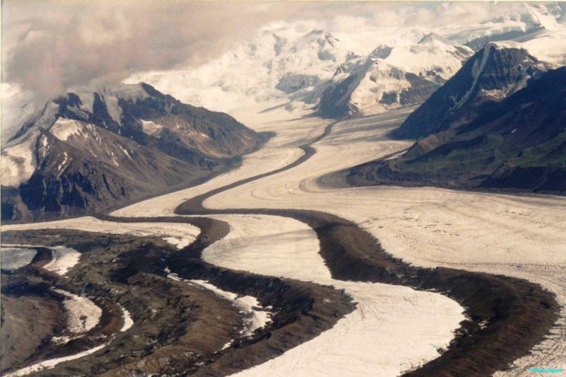
Aerial view of Alaskan glaciers and moraines
A shy child, I loved big spaces, preferably without too many people around. I used to pore, belly down on the carpet, over a blue covered Philips school atlas, feeling my soul being drawn to those areas with only a few dots on them showing settlements. Siberia, of course, left the imagination of an adolescent boy reeling, as a helium balloon might corkscrew wildly into the blue sky once released. Who could live in the deep green of coniferous forest and tundra that took days for a train to cross before reaching the world’s deepest lake, Baikal ? But this was an unreachable place for me; I knew only that Siberia was a place of exile, of hardships greater than I could bear, and on a scale I found hard to focus on. Even with a magnifying glass, trying to delve further, I could only see a mass of tiny dots on the page that I would imagine were individual trees merging to form the endless forest.
Then the vast breadth of the Sahara, coloured beige with some rocky parts here and there, was equally seductive – how could a town exist in the middle of such a hostile expanse? Tamanrasset held a promise of marvels unimagined because it could never get that hot in the north of England, what could you eat, let alone drink, in such a place ? Exotic place names like Timbuktu and Ouagadougou were real, too; I had looked them up, daydreaming in the library at school. But I knew even then that I didn’t much like beaches, which is (wrongly) how I envisaged that landscape; I was also aware that many expeditions, well versed and prepared, had foundered in such an arid unforgiving environment. I could never go there unaided.
Later I noticed the pink (British Commonwealth colour) expanse of Canada, and then the huge chunk of emptiness that was Alaska, detached from, and as big as the rest of the United States, or, as I came to know them, the lower 48. This definitely looked like a place which ticked all the right boxes, but had the added advantage of being a place I might negotiate myself, without the need for an expeditionary approach. Thousands of people had trekked and camped, by snowshoes and canoes to lay a claim for gold, or land; where it was possible for a mediocre life in industry or commerce to be exchanged for a life of discovery and self sufficiency.
I was hardly doing that, to be honest, but the parallel mindset stuck with me throughout my summer on the ‘wild frontier’. I’d been offered the job of leading half a dozen camping trips there, my experiences in Scandinavia had put me at the top of the list. I was thrilled to be venturing out into the land that one of my heroes, Barry Lopez, author of ‘Arctic Dreams’ had written so evocatively and extensively on, a landscape that was only just on a scale that humans could form a relationship with, could feel a part of, without becoming insignificant. I already knew a lot about Arctic and sub-Arctic environments from my college days, fieldwork in Iceland, lots of reading about people like John Rae and British navy ships sent to find a Northwest passage, but a great deal of physical Alaska was new to me. I had a week to learn it.
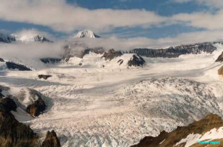
Extensive icefields are one image of Alaska but there are many more
In a gastronomic and temporal turmoil, I settled into the motel downtown to have a breakfast (straight out of the movies) with hash browns, eggs easy over and New York steak – with my belly 9 hours adrift. Afterwards I dozed, then slept, then dozed until I finally had to get up and take the shuttle back to the airport to pick up a hire car to make my recce. A nippy little Chrysler Neon would see me through alright and I threw my bags, maps and trip dossier into the boot (trunk, Bob) back at the motel after gingerly navigating unfamiliar traffic signs. All I knew was that I should be heading north, and this proved incredibly easy, as within 10 minutes I was looking at the open road, bordered by high mountains. By chance I spied a liquor store at the roadside and decided it was time to adopt my new persona, buying a six-pack of Coors beers and a bottle of Jack Daniels. As I was leaving, the guy on the counter helpfully mentioned the open container law, of which I was ignorant. It is illegal to have an open container of alcohol in the car, unless it’s in the boot, out of any possible reach for the driver. Worth knowing; I was hardly going to be nipping at my Jack’s en route, but an opened bottle in a bag behind the seat could land me in big trouble.
I passed a big road junction with the Glenn highway that I would meet from the other direction in a few day’s time and motored carefree until Wasilla where I spied a large supermarket. I’d anticipated I would be largely sleeping in the car and wanted some provisions to see me through a few days. I was astonished at the range of fresh produce, especially the salad bar where I piled up a container with goodies. In the north of Scandinavia fresh produce was never so plentiful, nor was it as fresh, except at a very high price; all this stuff was cheap as chips ! So with a stash of tasty and filling food, I was off again, passing Talkeetna on the way. I’d heard of Talkeetna as being the notional location for a late-night sitcom I enjoyed, called ‘Northern Exposure’ – I felt like I was on a tour of a huge film set ! Another change of perspective came when I stopped at a large lay-by (pull-out), where other vehicles had parked. This was the first view I was to have of Denali, formerly known as Mt McKinley, at 20,320ft, North America’s highest mountain, so I dug out my rations for a picnic and tucked in. Only when I’d finished did I realise there was nowhere obvious to put the debris, until I noticed an odd-shaped container that looked a little like the night deposit boxes found on the walls of a bank, you know – where you open the drawer, put your cash in and fold it back into the wall. A sign on the steel container described it as ‘bear-proof’, and warned of draconian penalties for anyone not using this facility. I guess the thought of the odd fox or badger clearing up picnic scraps at home wouldn’t really catch my attention, but this surely did.
From 50 miles away, Denali dominates the skyline
Meandering north I came almost to Healy and saw the signs for the National Park centre, which offered an informative exhibition with plenty of videos and leaflets on what you can and can’t do in this national park. I needed to find out about bears, about hiking and fishing and about how to see more of the park. Hiking was going to be problematic with a group of a dozen people of disparate abilities – you needed permits and bear-proof containers for any edible items, or indeed anything with an odour that might attract the attention of a hungry and curious bear. Access by private vehicles was only allowed up to the tarmac end (at mile 13, I think), where there was a bridge, unless you were booked as a guest at Kantishna Lodge, a wildlife resort at the end of the dirt road, some 80 miles distant. Otherwise, I figured the best way to see this place would be by buying tickets for the shuttle buses which ran frequently from the centre, and stopped briefly at several major points along the way like Polychrome and Sable Pass where toilets and short trails were accessible. You could hop on and off any bus which had space, but you had to make sure you were on the last bus out. That seemed to cover a variety of options and expectations for my groups who were unlikely to be hard-core hikers. I made note of the procedures involved for the next week when I would be with my first group.
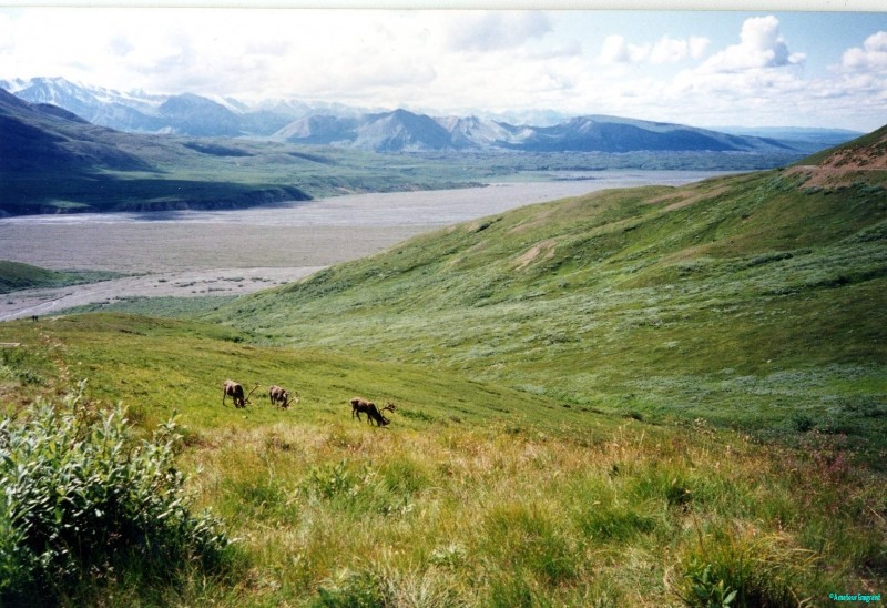
Caribou at Wonder Lake
Frankly, I was never disappointed with any of the bus shuttles (using the archetypal American school bus), although the seating was a little spartan for a 160 mile round trip to Wonder Lake. All the drivers I met had remarkable knowledge and insight into the early years of settlement here, as well as good wildlife awareness and skills; some were locals who may well have hunted and trapped in season here, but summertime brought much needed cash to the local economy so the jobs were highly sought after. In addition to being informative guides, they had a huge fund of anecdotes and great skill in driving a large vehicle on some tricky dirt roads. Their tolerance of the crazy ideas some visitors (especially whistle-stop tours from the cruise ships) was to be admired. One elderly lady nearly made me choke on a sandwich when she asked the driver ‘what time do they let the animals out ?’ They also swapped information on the state of the roads and anything that might be spotted en route from drivers returning from further up, and were invariably one of the first to spy the minute discontinuity or movement that indicated wildlife – even as small as a porcupine, which I discovered, to my surprise, were quite common. On the succeeding trips we often saw brown (grizzly) bears, moose (elk) and mountain goats with those massive ridged horns, scampering around cliff faces on flakes of rock, but only once did we see a distant wolf, no matter how much we imagined them.
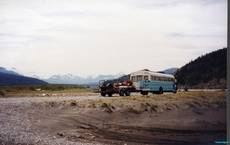
School bus type commonly used in Alaska
Heading on toward Fairbanks, I was now not far from where Chris McCandless starved in an old school bus in ’Into the Wild’ by John Krakauer. I got my first sight of rivers in the spate of break-up, the Teklanika and Nenana rivers, joining near the town of Nenana to flow into the Tanana river, now freighted with rafts and slabs of dirty ice churning under the bridge. A bar nearby was a good place for a break in future journeys, I noted, (especially pleased to see a good sized pool table !) I stayed over in Fairbanks in a caravan (trailer) on a small private campground, revelling in the hot showers – it wasn’t exactly summer temperatures yet (whatever they turned out to be). The owners were long-time residents of the town – it’s hard to see Fairbanks as a city – and a wealth of useful information and tips were absorbed. I asked about a place to get a meal and was directed to one nearby – I thought I would walk, but soon understood that few people do so, and that nearby was not nearby. Anyway I got there fine and ordered, but made the mistake of asking for a beer to be sternly told this was a family restaurant – doh ! This translates as no alcohol: there was much more than terrain for me to learn about, I was slowly finding out. I made note of the attractions of the town, the old-time houses (actually not much older than me now !), and paddle steamer, as well as the sumptuous salmon bake where huge meals (you could have steak if you preferred) were served on trestle tables in a folksy atmosphere, definitely a worthwhile eatery to visit, as I found that my own meal was free when I came with a group ! Although I was aware of the Dalton and Steese Highways heading north out of Fairbanks to the Arctic Ocean, it was not until later that I was able to venture out along these roads, now made famous (notorious) by the TV series ‘Ice Road Truckers’. Even then it was only a cursory visit, the highlight being several very successful games of pool.
Heading East from Fairbanks I seemed to be passing through a series of unremarkable newer dormitory settlements strung out along the famed Alaska Highway built after WWII to service early warning bases and enable troop movements through Canada. One such caught my eye, that of North Pole, which I suspect had been founded with the sole intention of frenetic marketing of Santa Claus and all that goes with it. Quirky, but you have to find ways of making a living up here, I sighed to myself.
Somewhere en route to Delta Junction I had my first sighting of the Alyeska Pipeline a constant presence when heading south to Valdez. This gargantuan project carrying still warm oil from Prudhoe Bay on the Arctic Ocean coast was at times raised above ground specifically to allow migratory animals to pass. It is constantly repumped, raising the temperature a little despite the heavy insulation that surrounds it. It was also heavily insulated by security measures from the surrounding population, as it is a strategic national resource as well as a significant environmental hazard in the delicately balanced landscape, and damage could be catastrophic. I soon reached Delta where I was to head south again. I hadn’t even reached the Arctic Circle here, but this terrain was definitely Arctic. In Scandinavia I’d actually swum across the line in a Swedish lake, and camped happily hundreds of miles north of that marker on the globe. It was a stark reminder of the beneficial influence of the Gulf Stream in the north Atlantic, which carried warmer waters right over the tip of Norway making their climate a lot gentler than here at the top of a continental landmass.
Something felt different about the landscape in some way as I headed south on the Richardson Highway, maybe there seemed to be fewer forested areas, maybe just the names of the little ‘towns’ some of which consisted of a roadhouse and half a dozen houses. Fort Greely, Slate Creek, Sourdough – they all had a more gritty pioneer feel to them. As the light was waning, I knew I needed to rest and take this in a little, and noticed a track signed off to a Bureau of Land Management campground. There was nothing there, a couple of picnic tables surrounded by willow and new pine scrub, and a circular track to park alongside. I decided to make a night of it in this quiet, isolated spot. I’d set up a little fire in a pit, writing up a few notes, chugging a few shots of Jack’s with a beer as I tended to the potatoes roasting in the embers and the juicy steak I’d brought from Fairbanks. I only had a knife with me so more elaborate meals were off the menu. Part way through my al fresco dining, I heard tyres slowly crunching along the dirt track and wondered what company might be arriving in this out of the way spot. At snails pace a rather beat-up pick-up emerged from the woods bordering the highway and set my mind racing – the middle of nowhere, they didn’t look like holiday makers, the two guys looking intently at my set-up, and I suddenly felt very exposed. They drew alongside and stopped, with the motor running, and greeted me in an offhand sort of way. “Y’all camping here ?” said the driver slightly lifting the brim of his bush hat. I said that I was hoping to, and asked if it was ok to do so. A moments thought ensued until the driver looked up again and slowly leaked out his opinion “Weeeell, yeah, but you take care, there’s bears in that there jungle . . . .” and with that they drove away still at snails pace, leaving me wondering; relieved, but not relieved. . .
Bears in that there jungle
I finished my food and feeling the pinch of a cold night coming on, I returned to the car, I’d been loaned a small tent by the people at the Fairbanks site and had been thinking of sleeping in it. Although it wasn’t late, I decided I’d retire to the spurious safety of the car, reclined the seats so I could sleep in my sleeping bag and then spent a fitful night listening for the clumsy passage of a grizzly, sniffing around where I’d been cooking. What a waste of energy, worrying can be !
Next day saw me heading toward what I thought would be one of the wildest parts of the tours I was about to run. One of the world’s largest areas of protected landscape is formed by the adjacent National Parks of Wrangell, in the USA, and St Elias, in Canada and any glance at the map will tell you it is almost entirely composed of glaciers and high mountains. We were not actually going far into that area, as it would require skills and self sufficiency beyond the scope of a two week camping trip. Nevertheless, wild it was !
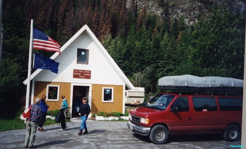
Motoring south after a hearty breakfast at a roadhouse, the land seemed to open further although the nature of the forested lowlands changing. Black spruce was much more in abundance – a shorter, darker woodland with a rather gloomy understory around the town of Glenallen, where I recce’d a campground for one of our overnight stops. For miles around here, I tried in vain to find a station on the car radio which was not based around rather earnest religious readings. Scripture with no choice seemed to me a bit oppressive, and I could have done with some good ol’ twangy country music, the usual Alaskan radio offering. Around Copper Center, and south to Willow Creek there was a spate of roadside artisan workshops, all seemingly devoted to the production of wooden artefacts, the commonest appeared to be the walking sticks and plaques made from Diamond Willow, a type which I’d never heard of, but extremely light in colour. Perhaps its very hard-wearing in the same way blackthorn is favoured in Britain? Anyway, I never got to find out because I turned off the highway at Willow to the East, signed McCarthy. Some distance down this road the tarmac ended at a little place called Chitina. I had a great lunch at the Roadkill Café and had a look around. There was a post office where you could get bumper stickers reading ’Where the Hell is Chitina? We know, but we ain’t telling!’ There was also a public water tap which I noted for future reference, as it would be our last source of treated water for the time we spent up at McCarthy.
Our van at Chitina P O Alaska “Where the hell is Chitina ? We know but we ain’t tellin”
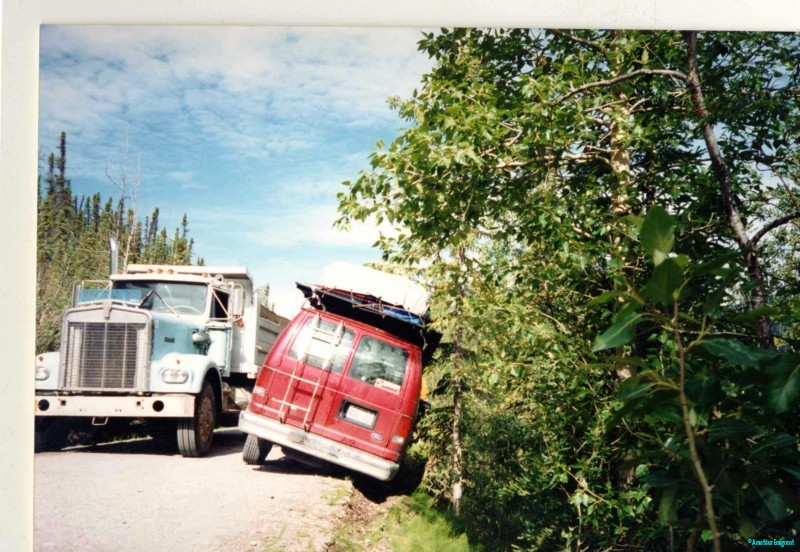
According to the hire car contract, I was not allowed to take the vehicle on dirt highways because of the damage from stone chips, but also specifically on the 60 mile road to McCarthy the high puncture hazard, as a result of the road being built atop the dismantled railroad. When the tracks were pulled up, I guess the creosoted sleepers were used for firewood, but the spikes holding the rails to them were just cast aside and covered with crushed stone. This was a bad mistake, because in wintertime the small amount of moisture beneath the spikes would freeze, and push the spikes toward the surface in time for the next tourist season. Travellers were urged to carry two spare wheels, and I only had one of the slim emergency spares, designed just to get you to the next garage. I would not be able to take that road until I came along on the first tour, and it would prove as difficult as it promised.
A truck the size of a house came along and plucked us from the roadside like a daisy
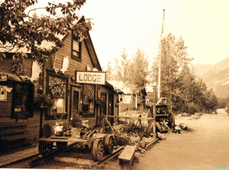
The road was narrow with plenty of passing places, but also plenty of places where you could easily skid down embankments at the sides, so speed was not of the essence. Getting to the end of the road was important as there were very few places to find assistance if needed. We passed quite a few large trucks in either direction but the scenery was limited by the jungly forest coming close to the road. Where the road crossed a creek or rounded a bend you were occasionally treated to expansive views of the post-glacial landscape. We would set up camp on the stony banks of the Kennicot River which emerged from the base of a glacier tongue just up the valley. The milky freezing torrent presented a problem for several months each year; in winter, of course, it was frozen and could easily be driven across, but summer visitors and supplies had to come in to McCarthy via a hand-operated cable car strung across the churning river, which had a really cold wind from the ice-cap following the river’s course. From here we would walk up to the scattered settlement, which looked very much like a Wild West film set. Pete McCarthy has an amusing account of his visit to his namesake town in ‘The Road to McCarthy’.
Bar and lodge at McCarthy
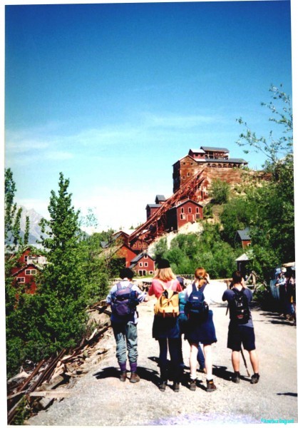
The Lodge had a well stocked bar and pool room, showers for hikers, hearty meals and an atmosphere redolent of the ‘49ers. Although the village seemed entirely geared to tourism, it was a year-round settlement, with a nearby airstrip for resupply and emergencies. It was the civil counterpart of the main industry of the area, which for many years had been extraction of copper ore, from the mines at Kennicot, a few miles up the valley. A track and a few walking trails led up to the dilapidated mine buildings, where rock used to be crushed, sluiced and separated to transport via the now defunct railway. There was an old-style (attempted upmarket) hotel created from the office buildings but the area was largely in a state of decorous industrial decay. The story of Kennicot came to an abrupt end when cheaper, more accessible deposits of copper were exploited in southern Africa in the early 20th Century. Prices collapsed and the mining stopped overnight forever.
Abandoned coppermine buildings at Kennicot; I thought six hikers had set off . . . .
Various trails led between and beyond McCarthy and Kennicot, some snaking up the open valley sides with breathtaking views over the glacier tongue and the ice-capped hinterland, but many led through new growth coniferous scrub which offered cover for the occasional black bear. Every time I walked there I was very cautious (being the group leader, I was always in front), and made plenty of noise; a surprised bear is not one you wish to encounter, and if they know you’re there, they’ll generally move away, (allegedly). Our riverbank camp was watched over by a couple of husky-type dogs who politely scrounged titbits from us and were much quicker than we would ever be to sense a bear in the vicinity. Nevertheless, all our supplies were carefully stashed when not required, in plastic boxes and stored inside the minibus we used.
My solo journey backtracked from Chitina to the Richardson Highway, again turning south toward Valdez. My overnight stop lay at the end of a short dirt road, a small car park with a information boards on the adjacent attraction, which was a huge tongue of the Thompson glacier tumbling down the hillside only a few hundred yards distant. I spent a quiet night, apart from the constant groaning and occasional crack from the glacier, but was very glad of the high-grade sleeping bag I had with me, as the air descending off the upper reaches of the glacier was utterly Baltic through the night. Sort of what you expect, Bob ? Doh !
Thompson glacier nightstop
The following day’s early start took me over the cusp of the Thompson Pass, which held a notorious reputation for the thousands of prospectors and adventurers who toiled up the trails with mules if they could afford them, carrying food supplies, mining paraphernalia and everything they might need to survive. The best time to mount the pass would be in spring, with the warmer weather in prospect and the snow crust still hard enough to make progress – any later and the mud would overwhelm many, exhausting their resources before they could get to any place where they might strike lucky. The winding road now seemed so easy by comparison as I coasted down to the busy port of Valdez set on the sea front despite a tidal wave and flood which had wiped out much of an earlier settlement. Valdez had a much more recent disaster too, the wrecking of the oil tanker Exxon Valdezin Prince William Sound where 10.8 million gallons of crude oil devastated the coastline and wildlife for years afterwards, although recovery was evident in many ways.
Fireweed, also known as Rosebay Willow herb carpets huge areas of open ground, a welcome blaze of colour
The seafront was composed of a string of eating places, fishing tackle and chandlers supplies, and small booths offering wildlife cruises in the surrounding area. It was also a major stopping point for the AMH – the Alaska Marine Highway – a vehicle and passenger ferry that operated up and down the coast in the same way Norway’s Hurtigruten reached settlements that could not be reached by land. With my groups I would be taking this ferry service past the Columbia glacier which dominated the region, through Prince William Sound to reach the terminus at Portage. En route we encountered spectacular views of wooded islets, extensive ice fronts calving into the frigid water and lots of mini icebergs clunking against the hull. From time to time someone would spot a whale breaching, or a bear plodding its way along the shore, forever scouring for any and all edible morsels, alive or dead. It was every bit as good as an expensive cruise, (provided you took your own picnic), and really showed us a whole new perspective on the landscape and its relationship with the sea, and could appreciate better the triumph of survival which Native Americans had forged along this coastline.
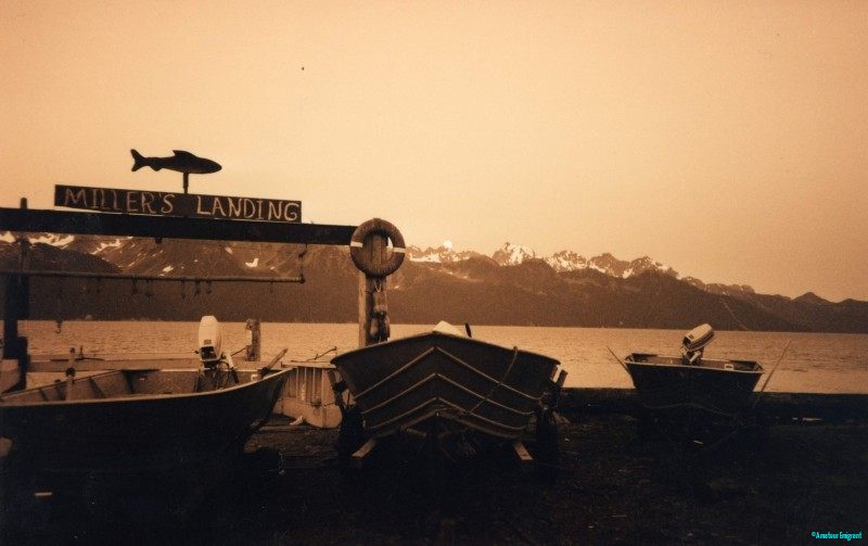
Our journey along the south coast took an unusual turn when we reached Portage. The name gives a clue, as this would be where you would have to start and carry your canoes, goods, supplies through the overlooking mountains. Today there is a rather incongruous rail station, where vehicles from the ferries queued to drive onto flatbed carriages. The train then set off, skirting the coast for a short while until it plunged through a long tunnel; we all sat in the minibus for this transit via the small town of – you guessed it – ‘Tunnel’ to reach the Kenai Peninsula. A complete change of landscape emerged, with dense old forest on the lower slopes of high snowy mountains, with an equally dense undergrowth of chest-high bramble-type plants, which we found were bear berries, through which we proceeded very carefully on our walks from our base at Millers Landing near to Seward.
Boats drawn up at Millers landing, with the site motif of a salmon. High mountains across the inlet
My own journey did not take in the AMH section, as it required pre-booking, but it was also less expensive for me to drive back up the Richardson Highway, taking the Glenn Highway Westward through Eureka Lodge on a very snowy road back to Palmer and then southward through Anchorage to the Kenai Peninsula; a long drive but full of spectacle brought me eventually to the tiny settlement and campground of Millers Landing. This was just the sort of place you would expect to meet hoary old sea-dogs, reeling off yarns of narrow escapes and unexpected bounty, settled in amongst aged barrels and coils of rope. And it lived up to my expectations entirely, there was even a fantastic goliath of a dog, a black Newfoundland which patrolled the area with nothing but the gentlest nature, and formidable enough to ward off any stray bear; I even had a little parking place that was signed as Camp Bob.
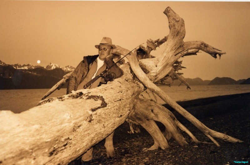
Gone fishing, Millers Landing, Alaska. At days end I often took off with a rod to go fishing
This became my favourite place on the 6 tours which I ran over the coming months. A great café in Seward served colossal breakfasts, there were a number of outfits that took wildlife cruises along the Kenai Peninsula with predictably high chances of seeing whales, orca, seals, bald eagles and lots of other indigenous marine life, and there were good places for me to fish while my groups were out on the briny. I even managed to get my bosses to pay for the $50 fishing licence which I amply justified by regularly catching whopping salmon which fed the whole group. My road now led back up to Anchorage to meet with the guy who would be driving our crewbus for the next 12 weeks, Dan, an east coast student who had travelled up the AlCan Highway on his own with a cargo of tents and cooking equipment. We would meet up at the motel in Anchorage, and meet our first group the following day.
Dan proved to be an affable and companionable lad; just out of college from a business studies course, he had travelled to Colorado which had rather relaxed rules about licenses for driving minibuses, which he duly acquired and set off on the long drive alone. I would have given anything to have been on that drive instead of the flight from Minneapolis to Anchorage, but it wasn’t practical; I only had three months on my visa-free stay, and the tours took up all of that, and a few illegal days afterwards. In any case, I suspected it was a policy of my company to arrange the initial meeting of strangers (who were to work together for months), at the last minute. I often only met the cook for my Scandinavian trips on the very afternoon that we would set off to Holland to pick up our leased bus. It seemed to ensure that you were obliged to find ways of getting on from the outset, and it seemed also to work.
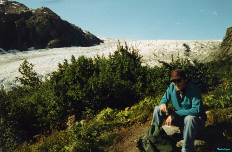
Dan, with baseball cap, perches on a stone to enjoy a picnic on a ridge near to a large glacier tumbling down hill
Dan’s principal role was as a driver and dogsbody; I was in charge as they were customers of my company, and we quickly settled that. He had never done anything like this before and so I was training him for quite a while. He could, however, cook a mean chilli, and often did so whenever we stopped somewhere for a couple of nights. It gave me a day off cooking and a diversion for him. He did manage to exhibit his ineptitude in other ways, though. When the rutted and corrugated road to McCarthy loosened some of the screws holding the roof ladder secure, he was in a panic to find a Ford garage for the right screws; I reassured him that self tapping screws of the right size could be found at any hardware store. He strangely seemed incapable of reconciling the amounts of money he had been issued with, deducting his allowable expenses and his own spending, so I was a little dubious about the validity of his business studies. He did boost my ego considerably on occasion, though; arriving in Glenallen one evening it was apparent that he had overlooked refilling the gas canisters in Fairbanks, and I promptly sent him off on a 50 mile round trip to get them filled before we headed out to McCarthy. In the meantime, I found some fence wire and bent it into a mesh, built and lit a fire and had cooked the evening meal for us all by the time he returned. He duly dubbed me Crocodile Dundee, just because I had lit a fire and cooked over it. Although he was very safe most of the time, on the McCarthy road he became a little blasé and the unforgiving surface promptly flung us into the ditch, held back from the steep slope only by spindly pines. We were lucky, as a monster truck (all Alaska trucks are monsters), had been only a half hour behind us. Dan also had a talent for attracting dogs which was very handy in out of the way places as they guaranteed a bear-free night.
In the middle of nowhere a log cabin with a US flag flying. Dan has attracted a black newfoundland dog that appeared out of the blue
It must be noted that this all took place in a summer in the mid ‘90s and a lot of things will have changed since then, but Alaska will not have changed much. I noted the other day that the company I worked for are still running the Alaska tour in very much the same format, except they have taken out the pretty boring bits around Fairbanks to Delta Junction, replacing this section with a crossing of the much wilder, exposed Denali Highway 50 miles south. To my dismay, but no doubt affording peace of mind, they have ditched the camping in favour of hostels and 2/3 star roadhouses.
To this improvement I feel obliged to refer to Wilfred Thesiger, of repute as a spartan traveller, in the 1930’s, who met Eric Newby and Hugh Carless in a wild spot high in the Hindu Kush, and after the usual sparse pleasantries, he learned they had inflatable mattresses in their tents; Thesiger bleakly remarked in his diary
“What a bunch of pansies those fellows must be !”
With alarming hubris, Bob Cranwell, Amateuremigrant


One thought on “Anchored down in Anchorage”
Fantastic read. I am going through it one day at a time…a slow, deep read. Love the painstaking detailing!